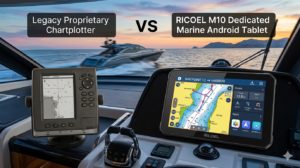
10″ Rugged Marine Android Tablet vs. Traditional Chartplotter: Which One Is Right for Your Vessel?
For decades, dedicated marine chartplotters from legacy brands have been the undisputed kings of the helm. However, the maritime industry is experiencing a digital shift. With the advancement of military-grade hardware combined with flexible consumer-level software, ruggedized marine Android tablets are rapidly emerging as formidable disrupters.
If you are a marine electronics distributor, commercial boat builder, or professional captain trying to decide whether a 10-inch rugged Android tablet can truly handle the open ocean compared to a traditional chartplotter, this comprehensive SEO-optimized breakdown will guide your decision.
The Advantages of a 10″ Marine Android Tablet
1. Cost-Effective with Infinite Map Flexibility
Traditional Chartplotters are notoriously expensive, and the hardware lock-in is just the beginning. To get detailed maps, users are often forced to buy proprietary regional SD card maps that cost hundreds of dollars each and require tedious manual updates via a computer.
The Marine Android Tablet provides a fraction of the hardware cost of a legacy system. Backed by full Google Play support, captains can freely choose from the world’s best navigation software (such as Navionics, Orca, or Aqua Map). Maps are updated instantly over Wi-Fi, and many apps offer superior global coverage at a significantly lower subscription cost.
2. Display and Touch Revolution (1000 nits & Wet-Finger Touch)
Traditional Chartplotters in the mid-range category often suffer from low-resolution screens, poor refresh rates, and capacitive touchscreens that either glitch when hit by a wave or require clunky physical buttons to navigate.
The Marine Android Tablet is built for extreme outdoor environments. It features a 1000 nits ultra-bright display, ensuring crisp, crystal-clear chart visibility under direct tropical sunlight. More importantly, it features specialized wet-hand touch control, allowing flawless navigation and pinching-to-zoom even in torrential downpours or heavy sea spray.
3. Multi-Functional Open App Ecosystem
Traditional Chartplotters do one thing and one thing only. Once you turn off your boat, the machine sits idle in the dashboard.
The Marine Android Tablet is a fully functional, high-performance Android computer. Out on the water, it tracks your precise route via an integrated multi-GNSS (GPS/BeiDou) system. At night or back at the marina, it becomes your entertainment and business hub. Captains can check weather grib files, manage boat charter bookings, answer client emails, or stream YouTube and Netflix.
The Limitations: Where Traditional Chartplotters Still Hold Ground
To maintain full transparency with your clients and users, it is important to understand where the tablet requires alternative setups compared to $2,000+ premium marine hardware systems:
1. No Native Sonar/Transducer Port
Traditional chartplotters feature heavy-duty, direct industrial ports on the back to hardwire “through-hull” sonar transducers for 3D depth-sounding and fish-finding.
The Android Solution: The tablet cannot be directly wired to a legacy analog transducer. However, modern anglers solve this easily by using Wi-Fi or Bluetooth-enabled smart sonars (such as Deeper or Garmin Cast), which stream live underwater fish data straight to the tablet app.
2. NMEA 2000 Integration Requires a Gateway
Commercial vessels use the NMEA 2000 network to view real-time engine data, fuel tank levels, and battery voltages directly on their chartplotter screens.
The Android Solution: The tablet cannot directly plug into an NMEA backbone cable. To read boat data, you simply need a standard NMEA-to-Wi-Fi gateway. This small device broadcasts the ship’s telemetry wirelessly, allowing advanced marine apps (like Orca) to display engine data flawlessly on the 10-inch tablet screen.
The Verdict: Which One Do You Actually Need?
🚫 This Marine Tablet is NOT for you if:You run a large commercial vessel that strictly requires an all-in-one, completely hard-wired dashboard hub integrated with legacy analog radars, black-box depth sounders, and physical marine bus cables…
⚓ This Marine Tablet is PERFECT for you if:You are a modern captain, professional angler, yacht owner, or small-craft operator who wants a beautifully vibrant, 10-inch primary or backup navigation display. You require a device that is 100% waterproof, easily readable in blinding sunlight, and tracks multi-satellite GNSS flawlessly…
Official App Download Links (Google Play Store)
- Navionics Boating (A Garmin Brand): https://play.google.com/store/apps/details?id=it.navionics.singleAppMarineLakes
- Orca: The Marine Navigation: https://play.google.com/store/apps/details?id=am.orca.app
- Aqua Map Marine & Lakes: https://play.google.com/store/apps/details?id=com.geomedia.aquamap
- MarineTraffic – Ship Tracking: https://play.google.com/store/apps/details?id=com.marinetraffic.android